Overview
Pilots, first responders, and command and control centers rely on live aerial video streams for scene intelligence and guidance during their mission-critical and lifesaving public safety operations. However, video feeds with inaccurate or delayed geographical information can result in dire consequences, putting lives in danger.
Precise geo-tagging for real-time aerial video.
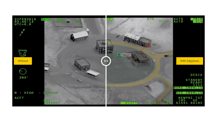
Visually augmenting roads, landmarks, and other mission-critical data on top of live video feeds, Edgybees brings unprecedented visibility even to the most complex and opaque disaster scenes. Delivering real-time, high-precision geo-tagging of aerial video, our AI-powered solution removes any ambiguity that stands in the way of rapid response and accurately locating rescue targets.
Battle-tested and mission-ready.
The Edgybees platform has been used to aid first responders in large-scale disaster areas, including during Hurricane Irma, Hurricane Florence, and the California wildfires. The platform is also used by multiple DOD departments including the USAF and Navy. We also partner with leading defense contractors and system integrators, who value our open system architecture and the power of our unique technology, to rapidly address various mission-critical use cases such as:
- Increase Situational Awareness
Improve operational effectiveness and safety with real-time augmented reality (AR) layers, including GIS, TACSIT, and ATC. - Reduce Time-to-Target
Execute operations faster by displaying accurate, mission-critical data in real-time over a single screen, minimizing cognitive load, and optimizing mission effectiveness. - Avoid Costly Mistakes
Avoid costly mistakes with enhanced accuracy, relevancy, and timeliness of aerial video feeds.
Integrated into your operational environment.
Edgybees software-only solution is an open platform that provides the ultimate deployment flexibility. While we offer robust video augmentation, you can also opt to use our metadata to enhance the accuracy of third-party systems and applications that are already used by your organization.
Details
Increase Situational Awareness
Improve operational effectiveness and safety with real-time augmented reality (AR) layers, including GIS, TACSIT, and ATC.
Reduce Time-to-Target
Execute operations faster by displaying accurate, mission-critical data in real time over a single screen, minimizing cognitive load and optimizing mission effectiveness.
Avoid Costly Mistakes
Avoid costly mistakes with enhanced accuracy, relevancy, and timeliness of aerial video feeds.
Images
Videos

Sorry, you must be logged in to view the rest of this page
Please log in or create an account to view more details.
Log in or Sign UpCustomers and Partners
Documents

Sorry, you must be logged in to view the rest of this page
Please log in or create an account to view more details.
Log in or Sign UpExpert Analysis

Sorry, you must be logged in to view the rest of this page
Please log in or create an account to view more details.
Log in or Sign Up


