Overview
A SINGULAR SCREEN
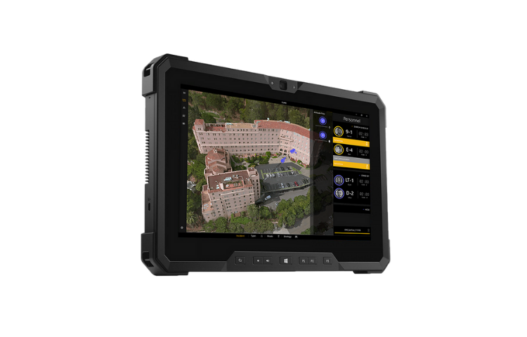
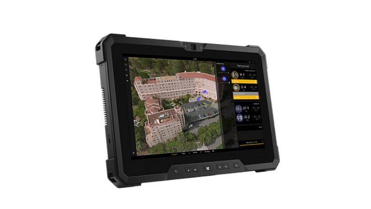
Florian is a software-based mobile command platform that gives you complete oversight over everything from incident pre-planning, total on-site awareness of your personnel and tactics as well as detailed records for your debrief & training. All on a singular screen that continues to be adaptive in the ever-evolving world that is emergency services.
- EN-ROUTE
- Interactive 3D Map screen
- Streetview
- Company ETA’s
- CIDS Reports
- Hydrant Locations
- Custom Tactical Reference Data
- ON SCENE
- Size-Up Snapshot Video
- Zoning Features For Automated Alerts
- Personnel Tracking For Resource MGMT
- Color Coordinated Companies
- On Map Scribbles for Quick Issue Orders
- Automated Mayday Recognition
- Cloud Sync Across all devices
- DEBRIEF AND TRAINING
- Incident Archiving
- Scrubbable Timeline with Playback
- Personnel History And Location Data
- Cloud Backup & Sync
Details
Maps
Size-up any incident digitally with a detailed 3D view that will assist with understanding the of the incident location prior to arrival
Mayday
Utilize our Artificial Intelligence to mitigate step-ons with an easy to understand mayday alert that grabs your attention
Roll Up
Keep track of your personnel with collapsible team views that help to reduce noise on the fireground
Replay
Detailed 3D post incident playback enabling powerful debrief and training opportunities
Evacuation
Set geo-fenced zones and alert the public in seconds to either evacuate or shelter in place
Size-Up
Capture geo-located video files to help understand the incident and and the severity
Tools
Create automated zones to know where your personnel are at all times
Images
Videos
Sorry, you must be logged in to view the rest of this page
Please log in or create an account to view more details.
Log in or Sign UpCustomers and Partners
Sorry, you must be logged in to view the rest of this page
Please log in or create an account to view more details.
Log in or Sign UpDocuments
Sorry, you must be logged in to view the rest of this page
Please log in or create an account to view more details.
Log in or Sign UpExpert Analysis
Sorry, you must be logged in to view the rest of this page
Please log in or create an account to view more details.
Log in or Sign UpExpert Analysis
“...when we limit our exposure to information, or when information itself is scarce, our picture of reality suffers. We become oblivious to both opportunities and hazards.”
- Chief John Salka- Cloud
- Communications
- GPS
- Interoperability
- IoT
- Location Tracking
- Police
- Pre-Incident Planning
- Sensors
- Situational Awareness & Detection
- 5G
- Actionable Intelligence
- Asset/Resource Management
- Cyber Security
- Disaster Response
- Drones/UAS
- Emergency Communications
- EMS
- Fire
- GIS/Mapping & Photogrammetry
- Remote Operations
- Responder Health & Safety
- Satellite
- Smart Cities
- Software
- Special Operations (HAZMAT, Search & Rescue, SWAT, etc)
- Video Surveillance
- VR & AR
- Wildfire
- 2D
- 3D
- 3D models
- 3D Vision system
- 3D visualizations
- 4G-LTE
- 5G
- 911
- Accident Management
- Actionable Intelligence
- Activity Monitoring
- Advanced imaging
- advanced tools
- ADVANCED VIDEO PLAYBACKS
- Aerial Drone Assets
- aerial view
- AI
- AI App
- AI software
- AI Technology
- AI Tool
- AI-POWERED
- Alerting
- Alerts
- Allerting
- Analytics
- android
- API access
- App
- Application
- Artificial Intelligence
- Asset Management
- Assets
- Audio
- Awareness
- Border Control
- CAD integration
- Camera
- cellular-denied environments
- Cloud
- Collaborative Communication
- Collaborative Response
- Communications Platform
- Connectivity
- Contact Tracing
- corporate security
- Crisis intervention responders
- Crisis Response
- Critical incidents
- Cross-platform
- custom data
- data platforms
- Data Visualization
- Direct Action
- Disaster Response
- Documentation
- Drone
- easy-to-use
- Emergency Alerts
- emergency communication
- Emergency Communications
- Emergency Departments
- Emergency Management
- emergency responders
- Emergency Response
- EMS
- Enhance Operational Efficiency
- enhance safety
- Enterprise
- Event Management
- Fire
- Fire Department
- Fire Departments
- First Responder
- First Responders
- FirstNet
- Fleet Management
- Florian
- Force Risk Reduction
- GPS
- GPS tracking
- HazMat
- high-quality
- High-resolution
- Highly Accurate
- Incident
- incident command
- Incident Management
- Incident Notifications
- incident response
- integrated mapping
- integrations
- Interoperability
- Investigation
- IoT
- life-saving technologies
- LIVE DATA
- Location
- Location Mapping
- LTE
- Management
- Mapping
- Mapping and Geotagging
- mapping software
- Mass Communication Platform
- mass notification systems
- Military
- Military Safety
- Mobile
- Mobile App
- Mobile Computing
- Mobile Devices
- Mobile Platform
- Mobile Software
- Mobility Intelligence
- Monitoring
- natural disasters
- Navigation
- network-based solution
- Observation
- Off-grid Communications
- officer solutions
- One End-To-End Solution
- operation
- Operational foresight
- Operational Optimization
- Operations Software
- Personal Safety
- platform
- Police
- Police & EMS
- Police Departments
- Portable Device
- Private Sector Solutions
- Private Security
- Public Safety
- Public Sector Solutions
- Quickly access
- real data
- real-time data
- real-time information
- Real-time location
- Reduce Risk
- remote
- Remote Operation
- Remotely Monitor
- rescue squads
- Responder Safety
- Response
- routing
- Saas
- safety
- Safety and Security
- Safety Solutions
- Satellite
- Saving lives
- scalability
- scalable
- Secure
- secure data transfer
- Security Agencies
- security cameras
- Sensors
- Situational Awareness
- Software
- tactical platform
- Tactical Tool
- Technology platform
- technology products
- track
- Tracker
- Tracking
- Unified Communication
- Video
- video evidence
- Video Streaming
- website archiving
- wireless data