Overview
Geospiza SWIFT™ Population Vulnerability Management
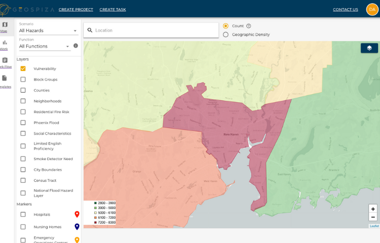
Geospiza SWIFT™ enables public safety, disaster, and homeland security organizations to make evidence-based decisions faster. By combining a constellation of mapped data sources and extensive population vulnerability models, users can easily navigate their communities, target limited resources, set metrics for success, and track ROI over time.
Our tool is intended for day-to-day use, where users can understand who is most vulnerable in their community and why. Using a model of access to communication, self-care, and transportation, we show the reasons why extra resources need to be deployed in a certain area.
Population data on dozens of factors like mobility, power dependence, limited English, and visual impairment are all seamlessly integrated into risk models that help bring light to those who suffer disproportionately in disaster, from an all-hazards perspective.
Because Geospiza is web-based and easily accessible, leaders can follow work in the field: actions, assets, surveys, and outreach can all be geotracked in real time, giving customers like Kansas City, MO the visualization they need to be most effective week after week.
Details
End users are viewing your products!
Make sure they have all the information they need.
If you own this product, sign in to complete this sectionImages
End users are viewing your products!
Make sure they have all the information they need.
If you own this product, sign in to complete this sectionVideos

Sorry, you must be logged in to view the rest of this page
Please log in or create an account to view more details.
Log in or Sign UpCustomers and Partners
Sorry, you must be logged in to view the rest of this page
Please log in or create an account to view more details.
Log in or Sign UpDocuments
Sorry, you must be logged in to view the rest of this page
Please log in or create an account to view more details.
Log in or Sign UpExpert Analysis
Sorry, you must be logged in to view the rest of this page
Please log in or create an account to view more details.
Log in or Sign UpExpert Analysis
"Sarah is a brilliant visionary who brings together people able to think past yesterday and look at how to innovate change for tomorrow. I am confident her work will lead others off the path of 'same old' and onto the freeway of 'can do' especially to benefit those most often left on the side of that road."
- Elizabeth Davis , Founder & Executive DirectorEAD & Associates, LLC


