Overview
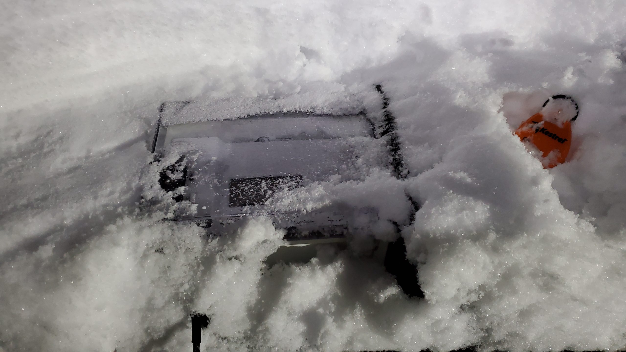
In Washington State during the 2020-2021 winter, we had the DropBlock buried under about 18″ of snow…and it was still transmitting to the satellite!
We ran a 6-Month pilot with Arapahoe County, Colorado’s OEM: The DropBlock performed flawlessly through 100+ degree heat and sub-zero freezing temperatures.
The summer of 2021 saw DropBlocks deployed on 7 different wildfires for their Dingell Act resource tracking abilities: All DropBlocks performed flawlessly and reliably without error. They are used by Wildland firefighters and proven by Wildland firefighters.
Details
Use Anywhere
The DropBlock provides reliable communications anywhere in the world with a clear view of the sky, rain or shine.
DropBlocks send/receive data in places where there is no cellular coverage and where mesh networks or VHF radios fail due to long distances or topography.
Images
End users are viewing your products!
Make sure they have all the information they need.
If you own this product, sign in to complete this sectionVideos

Sorry, you must be logged in to view the rest of this page
Please log in or create an account to view more details.
Log in or Sign UpCustomers and Partners

Sorry, you must be logged in to view the rest of this page
Please log in or create an account to view more details.
Log in or Sign UpDocuments

Sorry, you must be logged in to view the rest of this page
Please log in or create an account to view more details.
Log in or Sign UpExpert Analysis

Sorry, you must be logged in to view the rest of this page
Please log in or create an account to view more details.
Log in or Sign UpExpert Analysis
- AWS
- Cloud
- Communications
- Digital Dashboards
- GPS
- IoT
- Location Tracking
- Sensors
- Situational Awareness & Detection
- Actionable Intelligence
- Asset/Resource Management
- Data Analytics & Management
- Disaster Response
- Emergency Communications
- Fire
- GIS/Mapping & Photogrammetry
- Remote Operations
- Reporting
- Responder Health & Safety
- Satellite
- Software
- Wildfire
- Alerting
- Alerts
- Allerting
- Amazon
- analytics platform
- and government agencies
- and mining industries.
- and sharing of data
- android
- API access
- App
- Application
- Asset Management
- Assets
- AWS
- Border Control
- Business Development
- Businesses
- cellular-denied environments
- climate change
- Cloud
- cloud-based platform
- cloud-based solutions
- Collaborative Communication
- Collaborative Response
- Combat Proven
- commercial customers
- Communication
- Communications
- Communications Platform
- communications technology
- communications tool
- Connect
- connection
- Connectivity
- Crisis Response
- Critical incidents
- Cross-platform
- Custom Branding
- custom data
- customer service
- Customer Services
- Data Analysis
- Data Analytics
- Data Capture
- Data Control
- data platforms
- defender
- Defense
- Defense Operations
- delivery system
- Detection
- Device
- Digital
- Digital Dashboards
- Digital Platform
- Disaster Response
- Document Viewer
- Documentation
- Documents
- Effective Workforce
- Effectiveness
- Emergency Alerts
- emergency communication
- Emergency Communications
- Emergency Departments
- Emergency Management
- Emergency Medical Services
- emergency responders
- Emergency Response
- EMS
- Enhance Operational Efficiency
- enhance safety
- entrepreneur
- Fast Applications
- faster
- Fire
- Fire Department
- Fire Departments
- Fire Prevention
- First Reponder
- First Responder
- First Responders
- FirstNet
- Government
- GPS
- GPS tracking
- high-quality
- Highly Accurate
- Highly Scalable
- Homeland
- improve communication
- Incident
- incident command
- Incident Management
- Incident Notifications
- incident response
- Information
- Inspection
- Inspections
- instant
- integrated mapping
- intelligence communities
- Investigation
- IoT
- life-saving technologies
- Lightweight
- Lightweight Leading Edge
- LIVE DATA
- logistics solution
- Low Cost
- Mapping
- Mapping and Geotagging
- mapping software
- Mass Communication Platform
- Military
- Military Safety
- Mobile
- Mobile Ali
- Mobile App
- Mobile Computing
- Mobile Devices
- Mobile Platform
- Mobile Software
- natural disasters
- Navigation
- Network
- Off gassing hazards
- Off-grid Communications
- ommunication
- One End-To-End Solution
- operation
- paperless
- Personal Safety
- Personnel
- Planning
- portable
- Portable Device
- Pre-Incident
- public defenders
- Public Safety
- Public Sector Solutions
- Quickly access
- Rapid Response Network
- real data
- real-time data
- real-time information
- Real-time location
- Reconnaissance
- record
- Recording
- Reduce Risk
- remote
- Remote Operation
- remote work
- Remotely Monitor
- Reporting
- resilient systems
- Responder
- Responder Safety
- Response
- response coordination
- Saas
- Safety and Security
- Satellite
- Saving lives
- scalability
- scalable
- Secure
- secure data transfer
- security
- sensing devices
- sensor
- Sensors
- Services
- Situational Awareness
- Sky-high satellite
- SMS
- Software
- Software Platform
- Software Solutions
- startups
- Surveillance
- Surveillance analytics
- Tactical Device
- Tactical Divice
- tactical platform
- Tactical Satcom
- Tactical Tool
- Take Atak Off-Grid
- technologies
- technology
- Technology platform
- technology products
- technology solution
- Telecommunications
- Teleoperation
- track
- Tracking
- Transformative Technology
- Unified Communication
- Weather
- Web-based Software
- Wi-Fi
- Wifi
- Wireless Calls
- wireless data
- Wireless Traffic
- workflow software


