Overview
The RoGO DropBlock marks & tracks human and non-human Wildland Firefighting resources: DropBlocks are John Dingell Act compliant for tracking GPS location of Firefighters and their machinery. DropBlocks provide Situational Awareness to spiked-out Firefighters by reliably sending/receiving weather data and critical messages over low-cost satellite.
The RoGO DropBlock provides data communications anywhere over satellite; it works where mesh networks fail. Receive weather updates, receive IAPs, and send finger-signed timesheets from your smart device, and get up-to-the-minute weather information from remote, spiked-out, cellular-denied areas with the RoGO DropBlock.
The DropBlock also sends Wind Speed/Wind Direction, RH, Temp and more from a Kestrel 5500 device from remote areas back to the IMET or FBAN so the ICP knows what is going on where within the fire incident. Knowing where the fire is, where the wind is blowing to and where the GPS locations of Firefighters are saves lives and helps to align tactical efforts efficiently and effectively.
For Strike Force leaders and Task Force leaders, we offer a full IP, 700kpbs satellite connection so you can run full Incident Management platforms (like ATAK, Intterra or FiResponse) or fire predictive analysis platforms (like Technosylva, WiFire and more) in the middle of nowhere seamlessly.
Always be in the know, and always keep Firefighters safe from weather and hazards with RoGO Communication’s devices.
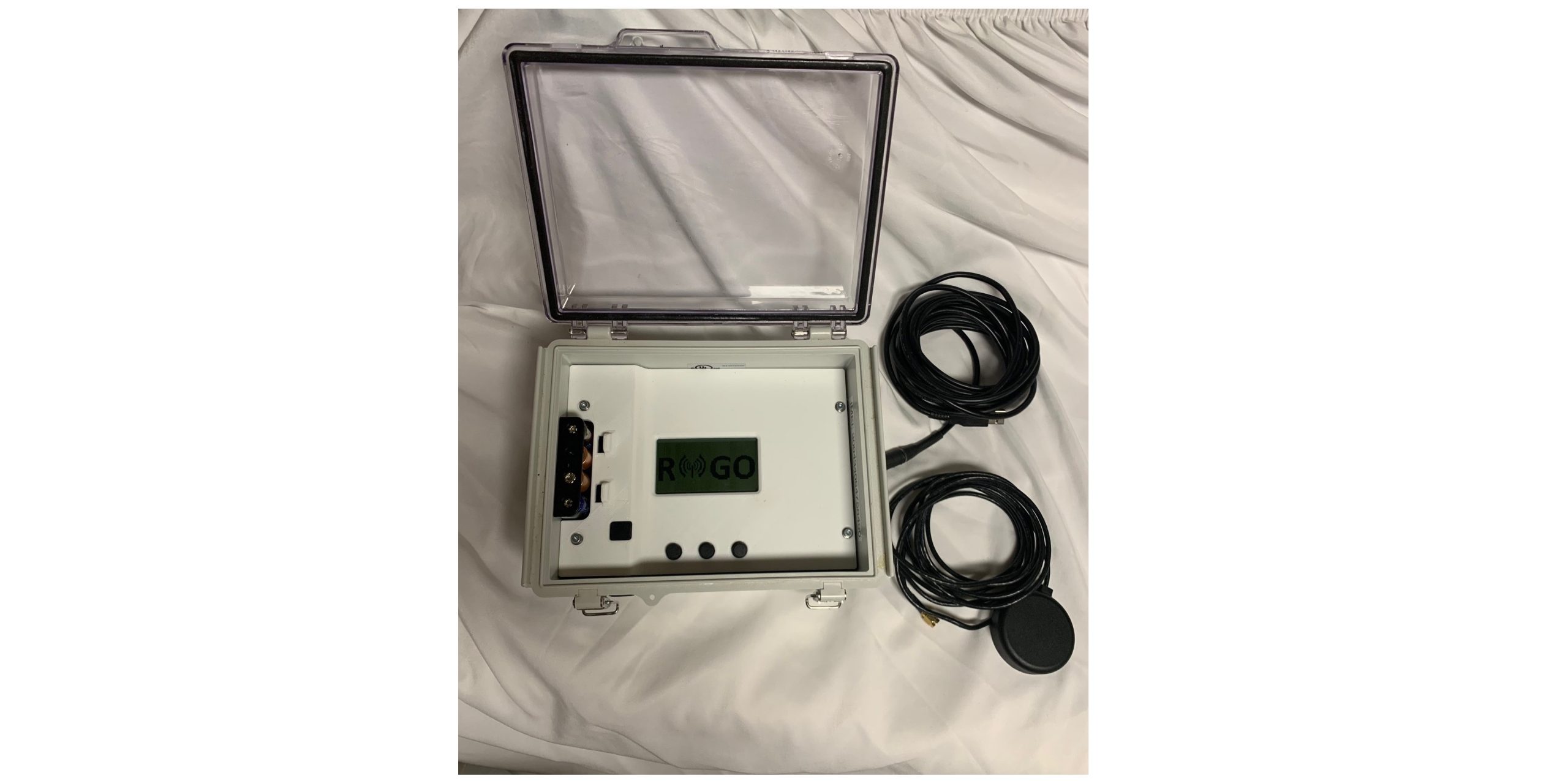
DropBlocks can be powered from any USB port, from 4 AA batteries available from any cache, or, for indefinite off-grid use, RoGO supplies a tested & proven solar panel & battery back-up combination to run the DropBlock running year-round.
Details
Reliable Communication
RoGO has had DropBlocks deployed on wildfires in 7 western U.S. states in the summer of 2021; all devices performed flawlessly and reliably with their Dingell Act resource tracking responsibilities and weather data reporting abilities. DropBlocks come in rugged IP67-rated cases. Weatherproof and waterproof.
Always be in the know with devices from RoGO.
Easily powered
DropBlocks can be powered from any USB port, from 4 AA batteries available at any firefighting cache, or, from a RoGO supplied solar panel and battery back-up combination. The solar panel and battery back-up will keep the DropBlock running off grid indefinitely for reliable year-round weather reporting.
Send Kestrel 5500 data
RoGO DropBlocks reliably transmit wind speed/wind direction data from Kestrel 5500 devices over satellite back down to all firefighters in the incident, and to the FBAN and IMET too. Now everybody can be in the know of what's happening now, and what the weather will bring in the near future, too.
Images
Videos
Sorry, you must be logged in to view the rest of this page
Please log in or create an account to view more details.
Log in or Sign UpCustomers and Partners
Sorry, you must be logged in to view the rest of this page
Please log in or create an account to view more details.
Log in or Sign UpDocuments
Sorry, you must be logged in to view the rest of this page
Please log in or create an account to view more details.
Log in or Sign UpExpert Analysis
Sorry, you must be logged in to view the rest of this page
Please log in or create an account to view more details.
Log in or Sign UpExpert Analysis
- AWS
- Cloud
- Communications
- Digital Dashboards
- GPS
- Interoperability
- IoT
- Location Tracking
- Pre-Incident Planning
- Sensors
- Situational Awareness & Detection
- Asset/Resource Management
- Data Analytics & Management
- Disaster Response
- Emergency Communications
- Fire
- Management & Governance
- Protective Equipment
- Quality Assurance
- Remote Operations
- Reporting
- Responder Health & Safety
- Satellite
- Security, Identity and Compliance
- Software
- Special Operations (HAZMAT, Search & Rescue, SWAT, etc)
- Tactical & Military Gear
- Wildfire
- Alerting
- Alerts
- Allerting
- Amazon
- and mining industries.
- and sharing of data
- android
- API access
- App
- Application
- Asset Management
- Awareness
- AWS
- Border Control
- cellular-denied environments
- climate change
- Cloud
- cloud-based platform
- cloud-based solutions
- Collaboration
- Collaborative Communication
- Collaborative Response
- Combat Proven
- Communication
- Communications
- Communications Platform
- communications technology
- communications tool
- Connect
- connection
- Connectivity
- Crisis Response
- customer service
- Customer Services
- Dashboard
- Data
- Data Analysis
- Data Analytics
- Data Capture
- Data Control
- data platforms
- Data recording
- Data Sharing
- Data Storage
- Data Visualization
- decision making
- defender
- Defense
- Defense Operations
- delivery system
- Detection
- Device
- Digital
- Digital Dashboards
- Disaster Response
- Effectiveness
- Emergency Alerts
- emergency communication
- Emergency Communications
- Emergency Departments
- Emergency Management
- emergency responders
- Emergency Response
- Enhance Operational Efficiency
- enhance safety
- entrepreneur
- Fire
- Fire Department
- Fire Departments
- Fire Prevention
- First Reponder
- First Responder
- First Responders
- FirstNet
- Government Agencies
- Government Contracting
- GPS
- GPS tracking
- high-quality
- High-resolution
- Highly Accurate
- Highly Scalable
- Homeland
- Human Trafficking
- improve communication
- Incident
- incident command
- Incident Management
- Incident Notifications
- incident response
- Information
- integrated mapping
- integrations
- IoT
- life-saving technologies
- Lightweight Leading Edge
- LIVE DATA
- Local Government
- local governments
- Location
- Location Mapping
- Logistics & Delivery
- Low Cost
- Mapping
- Mapping and Geotagging
- mapping software
- Mass Communication Platform
- micro-environmental
- Mobile
- Mobile Ali
- Mobile App
- Mobile Computing
- Mobile Devices
- Mobile Platform
- Mobile Software
- Mobility Intelligence
- Modern Customer Service
- natural disasters
- Navigation
- Network
- network hardware
- network-based solution
- networking
- Off-grid Communications
- ommunication
- One End-To-End Solution
- Operational Optimization
- Operations Software
- Operator
- paperless
- Personal Safety
- Personnel
- portable
- Portable Device
- Pre-Incident
- protection
- public defenders
- Public Safety
- Public Sector Solutions
- Quickly access
- Rapid Response Network
- Re-ignition hazards
- real data
- real-time data
- real-time information
- Real-time location
- Records management
- Reduce Risk
- remote
- Remote Operation
- remote work
- Remotely Monitor
- Reporting
- resilient systems
- Responder
- Responder Safety
- Response
- response coordination
- Saas
- safety
- Safety and Security
- Safety Cloud ensures
- Safety Cloud to reduce the risk
- Safety Solutions
- Satellite
- Saving lives
- scalability
- scalable
- Secure
- sensing devices
- sensor
- Sensors
- Situational Awareness
- Sky-high satellite
- SMS
- Software
- Software Platform
- Software Solutions
- Soldier Systems
- startups
- Storm Alerts
- Tactical Device
- Tactical Divice
- tactical platform
- Tactical Satcom
- Tactical Tool
- Take Atak Off-Grid
- technologies
- technology
- Technology platform
- technology products
- technology solution
- Telecommunications
- track
- Track power
- Tracker
- Tracking
- training platform
- Training Tracker
- Transformative Technology
- Unified Communication
- vehicle data
- visual intelligence
- visualize
- Visualizing
- Wi-Fi
- Wide-Area Surveillance
- Wifi
- Wireless Calls
- wireless data
- Wireless Traffic